October 15, 2009
I've Moved
Firefighter Blog has moved. I would be honored if you
CLICKED HERE to Visit the Newly Designed FirefighterBlog.com!
See you there...
CLICKED HERE to Visit the Newly Designed FirefighterBlog.com!
See you there...
Labels: fire bloggers, Firefighter Bloggers, Hasta La Vista, WordPress
October 13, 2009
President Employs Diplomacy to End Wildfire
October 12, 2009
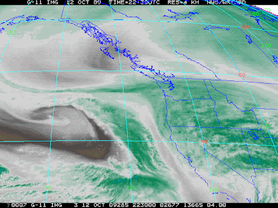
West Coast Storm May Trigger Slides
Remnants of a typhoon that blasted Japan last week is approaching the California coast today and should impact the state through into the weekend. Especially vulnerable are communities downstream from areas that burned this Summer.
Some of the communities in danger include Altadena, Montrose, La Crescenta, La Canada, Sylmar, Davenport, Fillmore and Oak Glen. Parts of Santa Barbara and Monterey Counties will be on slide alert as well.
The National Weather Service has issued gale warnings and flood advisories for much of the California coast.
Weather Service narrative
MODERATE TO HEAVY RAIN IS LIKELY ACROSS VENTURA
 AND LOS ANGELES COUNTIES AS WELL.
THIS HEAVY RAINFALL MAY CREATE SIGNIFICANT HAZARDS
IN AND AROUND RECENT BURN AREAS...WITH A THREAT OF
FLASH FLOODING AND DEBRIS FLOWS OVER THE BURN AREAS
OF SANTA BARBARA COUNTY. THE THREAT OF FLASH FLOODING
MAY SPREAD INTO THE BURN AREAS OF VENTURA
AND LOS ANGELES COUNTIES ON TUESDAY AND WEDNESDAY.
RESIDENTS OF SOUTHWESTERN CALIFORNIA...ESPECIALLY
THOSE WITH PROPERTY OR INTERESTS IN AND AROUND THE
RECENT BURN AREAS SHOULD STAY TUNED TO
LATER FORECASTS AND EXPECTED IMPACTS FROM THIS
STORM SYSTEM. STRONG SOUTHEAST TO SOUTH WINDS ARE
EXPECTED TO DEVELOP ACROSS SAN LUIS
OBISPO COUNTY AND MUCH OF SANTA BARBARA COUNTY TUESDAY
MORNING...AND CONTINUE INTO TUESDAY NIGHT.
DAMAGING WINDS GUSTS TO 60 MPH ARE
POSSIBLE. IN THE MOUNTAINS OF VENTURA AND LOS ANGELES
COUNTIES...STRONG SOUTH WINDS ARE EXPECTED TO DEVELOP
TUESDAY AFTERNOON AND CONTINUE THROUGH NOON WEDNESDAY...
WITH DAMAGING WINDGUSTS TO 60 MPH POSSIBLE.
October 04, 2009
Wrightwood Evacuated as Sheep Fire Advances
Update: The threat to the town of Wrightwood has been diminished. Winds subsided and firefighters have been conducting firing operations just east of the town. Air ops was just overheard on the scanner telling operations the fire looks "comfortable".
ABC7.com's helicopter is having trouble finding live flame to film on the western head of this fire.
Via InciWeb:
All of Wrightwood Now Under Mandatory Evacuation
Incident: Sheep Wildfire
All of Wrightwood is now under a mandatory evacuation. An evacuation center has been established at Victorville Fairgrounds at 14800 7th Street in Victorville.
For comprehensive coverage of the Sheep Fire check out Rim Of The World.
Follow Twitter Search for real time updates from locals, fire authority and bloggers.

Labels: 2009 Fire Season, Sheep Fire

