June 30, 2008
Lightning In Northwest May Expand Western Fire Count

Labels: 2008 Fire Season
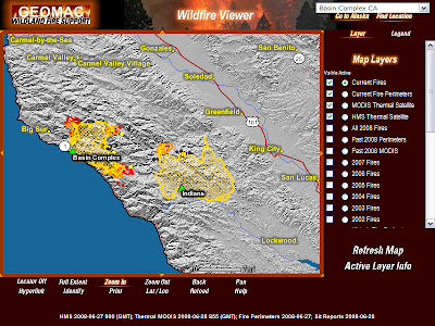
Basin Complex Fire Slows, Indians IC Adding Acreage
Today's observed fire behavior:
West Zone: "Fire behavior moderated in all areas with backing and creeping."
East Zone: "Active runs above 2000 ft elevation. Smoldering and creeping in drainages and below 2000 ft."
 Meanwhile on the Indians Fire the plan seems to be "tidy up" by burning out any green areas left on the north flank of the fire. You can see clearly how they are trying to fill in the blanks by intentionally blackening any green (unburned) areas within the fire perimeter.
You will recall from the earliest ICS-209 reports filed over one month ago the current IC predicted the fire would grow to 80,000 acres.
He'll be right.
Meanwhile it appears they experienced some slopover from the operation. We'll see what becomes of that tomorrow.
Labels: 2008 Fire Season, Basin Complex, California Firestorm 2008, Indians Fire
Basin Complex PM Wind Shift June 30
The winds shifted mid-day and as you can see by the image and animated loop the smoke columns for the Basin Complex, Indians Fire and the Piute Fire across the Central Valley in Kern County moved approximately 60 degrees in the matter of an hour.
*Blogger being a bit buggy at the moment so I can't upload the image. I'll try later.
Labels: 2008 Fire Season, Basin Complex, California Firestorm 2008
Big Sur Fire: Historic Event In The Making
Note too how the Indians Fire has blown containment on the N/E.
This is a beautiful forest and is very sad to witness. I believe both fire managers are doing everything in their power to bring these conflagrations under control. Sadly they don't have the resources to confront it properly. Two thousand firefighters is about 1/4 of the manpower they need to make a dent.
The morning report indicates 40,000 acres with 3% contained for the Basin Complex Fire. The Indians Fire says 61,000 acres with 89% containment. I believe that containment figure will be revised downward.

Labels: 2007 fire season, Basin Complex, California Firestorm 2008
Piute Fire, Follow By Webcam

Size 2,560 acres, 4 percent contained burning in Kern County. Yesterday the MAFF's C-130's and Tanker 910 threw everything they had at it.

Labels: 2008 Fire Season, California Firestorm 2008, Piute Fire
Big Sur Fire Causes Concern for Condor Keepers
If you have a moment take a look at these short videos. You can see why these magnificent birds attract such concern.
Labels: 2008 Fire Season, California Firestorm 2008
June 29, 2008
California Fires Map From Cal Fire & OES June 29

.
Satellite Image of California Fires Updated June 29
 Click the image to enlarge or visit MODIS Rapidfire for an expanded view of this remarkable enhanced satellite image of the California fires. The fire in the lower right portion of the image is the Piute Fire, a new fire burning in Kern County.
For perspective I added an image of fires burning out of control in Russia. Not such a fuss is made of forest fires in Siberia.
.
Labels: 2008 Fire Season, California Firestorm 2008
Big Sur Fire; Basins Complex View June 29,2008
Keep in mind 1,000 firefighters on scene means one half are on the lines and the other half are getting sleep. The fire only has 17 hand crews and 11 bulldozers assigned. Of the 1,000 firefighters nearly 20 percent are designated "overhead". These are division and group supervisors, incident command team members, biologists etc..
While they support efforts of the actual firefighters they do not lay shovels to the ground. Fifty or so firefighters comprise the two in-camp kitchen crews and their supervisors. Forty four fire engines are assigned to the Basins Complex and are primarily used for structure protection according the incident report. Structure protection engines and crews prep individual properties and lay in wait for the fire to come to them.
In reality no more than a few hundred firefighters and the eleven dozer operators are on the ground on any one shift. From the sky seven helicopters and seven fixed wing craft pound the flanks and support the hand crews working below. It's a decent air force but they cannot put the fire out without adequate ground support.
All considered this is a very small army for a fire this size. Fire command is really doing all they can with what they are given. Save structures, try to guide the fire away from local communities and hope for helping weather. Troops are scarce statewide so it's improbable this one will ever get adequately staffed. If so we'll likely see 170,000 acres burned as noted by Basin Complex command staff yesterday.

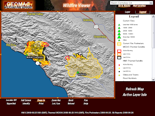
GeoMAC fire mapping software is fantastic. If you haven't played around with the fire map viewing options you should have a look.
*Update: Basins Complex continues run to the northwest-----

.
Labels: 2008 Fire Season, Basin Complex, California Firestorm 2008
June 28, 2008
Big Sur's Basin Complex a Three Headed Monster
If you look at the path the Basins Complex is taking you can make a case the south flank could run to Nacimiento-Fergusson Road. In this case firefighters could then tie the Basin Complex to the burned areas of the Indians to the east and the Pacific Ocean to the west.
The north flank of the fire should be helped by prevailing N/W winds once they return. The eastern head of the Basin Complex looks like the headache for fire command.
The morning report projected the final size at 170,000 acres. Most of this acreage has to come from acreage gained on its journey east. In order to get to 170,000 acres you have to look out as far as the lower Carmel Valley.

It seems almost inconceivable at the moment to suggest the fire will travel that far but I can't see how else they can get to 170K acres. Residents of lower Carmel Valley will get early clues if they begin seeing bulldozers unloading on the Valley floor to begin constructing or fortifying trails along the first line of ridges running the length of lower Carmel Valley.
These are only my back of the napkin thoughts. For a formal narrative read Sur Coast updates.
Labels: 2008 Fire Season, Basin Complex, California Firestorm 2008, Indians Fire
California Fires Map & Satellite Image June 28, 2008

View Larger Map
Labels: 2008 Fire Season, California Firestorm 2008
Officials: Big Sur Fires May Exceed 250,000 Acres
This morning's ICS-209 report for the Basin Complex Fire, now called Basin Complex West includes an estimated final size at 170,000 acres. The Basin Complex West fire will come close to matching the Marble-Cone Fire of 1977 that consumed 178,000 acres on the same ground.
The Indians Fire management team has stated since the start of the fire in May they expect their fire to exceed 80,000 acres. The fire has burned over 60,000 acres so far.
Wikipedia maintains a list of the largest wildfires in California history as;
1 - Santiago Canyon Fire of 1889: 300,000 acres ·
2 - Cedar Fire: 273,246 acres
3 - Zaca Fire: 240,207 acres
4 - Matilija Fire: 220,000 acres
5 - Witch Fire: 197,990
6 - Laguna Fire: 175,425 acres
7 - Marble-Cone Fire: ~178,000 acres
8 - Day Fire: 162,700 acres
9 - McNally Fire: 150,670 acres
10 - Old Fire: 91,281 acres
11 - Harris Fire: 90,440 acres (366 km²)
If the Basin Complex West and Indians Fire meet the stated expectations the combined acreage could challenge the Cedar Fire of 273k acres. Worth noting both current fire managers were in command of the Zaca Fire (#3 all time) at various stages last year.

(Please link back if you use this post)
Labels: 2008 Fire Season, Basin Complex, California Firestorm 2008, Indians Fire
June 27, 2008
Big Firefighting Weapons Assemble In North State
Tanker 910 is also spiked in Sacramento making runs where needed throughout Northern California.
Tanker 910 can deliver a 20,000 gallon payload. Martin Mars can drop 7,200 gallons per load and can reload on a good sized lake.
Tanker 910 in action over the Humboldt Fire.
C-130 test drop.
Labels: 2008 Fire Season, California Firestorm 2008
State Burns; Business as Usual on Indians Fire
The Indians Fire ICS-209 report filed tonight indicates the firing operation was carried out in the face of 16 mph winds from the east, towards the Basin Fire less than three miles downwind.
 I've followed this fire more closely than others burning in the state because it is close to my place and I sensed early on this fire could be a candidate for mismanagement. The $36,000,000 price tag to date and hoarding of personnel, when others begged for resources has not altered my suspicions. Maybe they don't realize how close they are to the Basin Complex? It almost appears as though they were persuading their fire to move east.
If this is their long range plan then it means they intend for the two fires to merge. The Basin Fire (26,000 acres 3% contained) hints so in their June 27 pm ICS-209.
Remarks:
"Plans are being implemented to zone the Basin Complex with Indians Fire command team. Damage assessment continues. Containment value remains static due to defensive actions. The Basin Complex is in unified command with USFS, Big Sur Volunteer Fire Brigade and Monterey County Sheriff's Office. "
If the fires meet in the middle on their own I have no problem. If the fires are being directed to meet I suggest the forest is a victim of mismanagement.
The Molumby crew has been consistent from the beginning his fire would be an 80,000 plus acre event. He'll be dead on if he pushes his fire into the Basin Fire. Dead on for his Indians Fire contribution. A combined Basin/Indians perimeter could easily combine to take out 125,000 acres.
The Ventana Wilderness deserves better than this.
.
Labels: 2008 Fire Season, Basin Complex, California Firestorm 2008, Indains Fire
Redding at Geographic Center of California Firestorm
A partial list of major fires and clusters, (complex) surrounding Redding include The Lime Complex, Iron Complex, Hell's Half Complex and the Whiskeytown Complex burn west of Redding. The SHU Lightning Complex burns north of the city, while the Cub Complex, Antelope and Mill Fires burn the the east.

The editorial staff of the Record Searchlight has been kind enough to recognize firefighters with a firefighter thank you page. If you have a moment click over and leave a message.
Labels: 2008 Fire Season, California Firestorm 2008
Air National Guard MAFFS C-130's To The Fires
 Military sends four National Guard MAFFS C-130's!
"The aircraft are a part of the North Carolina Air National Guard's 145th Airlift Wing based at Charlotte-Douglas International Airport.
The aircraft with nearly 50 North Carolina guardmembers are conducting airborne firefighting missions from a staging area near Sacramento, Calif. Two C-130s carry modular airborne fire fighting systems (MAFFS).
Since 1974, MAFFS has saved land, lives and property from wild land fires in the United States and abroad. MAFFS is only activated when all other air tanker resources are committed.
The MAFFS mission equips C-130s with a firefighting apparatus that is loaded into the aircraft’s cargo area. The MAFFS unit itself is a series of pressurized tanks that hold 3,000 gallons of flame-retardant liquid.
Directed by ground crews, and led to the fire site by a U.S. Forest service lead plane, MAFFS aircraft drop retardant along the leading edge of a fire to block the spread of flames.
The North Carolina contingent is operating two C-130s equipped with MAFFS modules. Two other C-130s are transporting equipment and personnel."
Photo credit Wyoming Air National Guard.
.
Labels: California Firestorm 2008
California Fires; Weather Spanking Underway
The inversion is about to lift. The satellite image below shows smoke from the north state blowing west, out to sea. This S/W wind is will lift the inversion and give fires new breath.

NOAA animated loop
If you look at the predicted weather today for the Walker Fire near Clear Lake you see winds from the ESE at 11:00am turning to WSW by 3:00pm.
This is where firefighters will find the most danger, (reference Firefighters Watchout Situations #15 below) once the front moves in. Later in the evening lightning is forecast. Expect little relief from any precipitation, expect new fires will result from dry lightning.
--------------------------------------------------------------------------------
Standard Firefighting Orders
1. Keep informed on fire weather conditions and forecasts.
2. Know what your fire is doing at all times.
3. Base all actions on current and expected behavior of the fire.
4. Identify escape routes and safety zones and make them known.
5. Post lookouts when there is possible danger.
6. Be alert. Keep calm. Think clearly. Act decisively.
7. Maintain prompt communications with your forces,supervisor,and adjoining forces.
8. Give clear instructions and insure they are understood.
9. Maintain control of your forces at all times.
10. Fight fire aggressively, having provided for safety first.
18 Watchouts Situations
1. Fire not scouted and sized up.
2. In country not seen in daylight.
3. Safety zones and escape routes not identified.
4. Unfamiliar with weather and local factors influencing fire behavior.
5. Uninformed on strategy, tactics, and hazards.
6. Instructions and assignments not clear.
7. No communication link with crewmembers/supervisors.
8. Constructing line without safe anchor point.
9. Building fireline downhill with fire below.
10. Attempting frontal assault on fire.
11. Unburned fuel between you and the fire.
12. Cannot see main fire, not in contact with anyone who can.
13. On a hillside where rolling material can ignite fuel below.
14. Weather is getting hotter and drier.
15. Wind increases and/or changes direction.
16. Getting frequent spot fires across line.
17. Terrain and fuels make escape to safety zones difficult.
18. Taking a nap near the fire line.
Labels: 2008 Fire Season, California Firestorm 2008, Standing firefighting orders
June 26, 2008
Basin Complex Looking Like Marble-Cone Fire #2
Chief Penny saw this coming;
"“The area is screaming for more proactive prevention,” he says. “It’s very easy to do it, it’s just the will. There is a need for supplemental funding because of sudden oak {death}.
“It’s a crisis now. It just hasn’t become a political crisis because nobody’s been killed, nobody’s house has burned up, no roads have washed out.”
In 1977 90% of the Ventana Wilderness was scorched by the 178,000 acre Marble-Cone Fire.
Marble Cone was fed by dead limbs from unusual snow fall seasons before. The Basin Complex Fire is fed by "sudden oak death", a plague decimating tan oaks in Santa Cruz and Monterey Counties. An example of sudden oak death can be seen in a webcam photo capture from the Big Sur webcam at Nepenthe Restaurant. Notice the dead tree in the center of the image.
 The Marble-Cone Fire may have been fueled by dead limbs but the fire was actually surrounded by responding state and federal crews in the initial stages. My cousin was one of those firefighters who had the fire in check when they were ordered to put down their chain saws. An approaching bulldozer was stopped in its tracks. The fire was in a "Wilderness" and no mechanical equipment is allowed in a designated wilderness.
I'll never forget my cousin shaking his head when he first told me this story. They had it stopped at 100 acres.
I'm not sure if an exemption was asked for or granted for this incident but you have to hope it was. As it stands tonight the fire is at 26,000 acres, 97% of which is uncontained fire line with multiple heads. The Ventana Wilderness is a precious resource.
The prophetic words of Chief Penny are coming back to haunt. The Angora Fire at Lake Tahoe last summer was fed by downed and dead trees. A debate continues who was at fault for not allowing clearing the deadwood. Two hundred fifty homes were lost there. Sixteen homes have been lost so far in Big Sur. One resident was told by a fire official the "big box" estimate for the Basin Complex is 250,000 acres.
.
Labels: 2008 Fire Season, Basin Complex, Big Sur, California Firestorm 2008, Marble Cone
California Fires Roundup June 26, 2008
Acres: 230,497
New fires: 3 Fires contained: 1
Northern California Joint Information Center - Call 530-226-2749.
Full NIFC report here.
More detail on each fire can be read here.
American River Complex (Tahoe National Forest): 1,750 acres at five percent contained. This complex of three fires is 11 miles northeast of Foresthill. Power lines and cultural resources are threatened. Information: Call (530) 478-6101.
Antelope (Lassen National Forest): 600 acres at an unknown percent contained. This fire is seven miles southeast of Paynes Creek.Information: Call (530) 257-9553.
Basin Complex (Los Padres National Forest): 20,600 acres at three percent contained. This complex of two fires is five miles southeast of Big Sur. Several residences are threatened and evacuations are in effect. Highway 1 is closed. Information: Call (805) 961-5770 or visit the web site (click on Current Conditions).
Blue (Six Rivers National Forest): 225 acres at five percent contained. This fire is 12 miles northeast of Klamath. Information: Call (530) 478-6101 or visit the web site.
BTU Lightning Complex (Butte Unit, Cal Fire): 7,000 acres at five percent contained. This complex of 27 fires is in Butte county. The communities of Jonesville, Butte Meadows and Concow are threatened and evacuations are in effect. Highway 70 is closed.Information: Call (530) 538-7826 or visit the web site.
Canyon Complex (Plumas National Forest): 5,291 acres at five percent contained. This complex of 34 fires is 16 miles northeast of Paradise. Residences and archeological sites are threatened and road closures are in effect. Information: Call (530) 283-7883.
Clover (Sequoia National Forest): 13,400 acres at 15 percent contained. Residences are threatened.Information: Call (760) 376-3781 ext. 625.
Corral (Lassen-Modoc Unit, Cal Fire): 1,740 acres at zero percent contained. This fire is 23 miles west of Termo.Information: Call (530) 257-9553 or visit the web site.
Cub Complex (Lassen National Forest): 1,600 acres at five percent contained. This complex of four fires is 16 miles southwest of Chester. Smoke is impacting communities in the area.Information: Call (530) 257-9553.
NEW Gould (Klamath National Forest): 350 acres at 20 percent contained. This fire is near Etna. It burned actively yesterday.Information: Call (530) 493-1518.
Hell's Half (Six Rivers National Forest): 1,142 acres at six percent contained. This complex of two fires is eight miles southwest of Burnt Ranch. Structures are threatened. Information: Call (707) 441-3623 or visit the web site.
Humboldt Complex (Humboldt-Del Norte Unit, Cal Fire): 1,050 acres at 50 percent contained. This complex of two fires is in Humboldt county. Several residences are threatened. Information: Call (707) 726-1225 or visit the web site.
Indians (Los Padres National Forest): 58,872 acres at 71 percent contained. This fire is 18 miles west of King City. Numerous residences and cultural resources are threatened.
Evacuations are in effect for Aroyo Seco. Information: Call 805-961-5770 or visit the web site.
Iron Complex (Shasta-Trinity National Forest): 4,500 acres at five percent contained. This complex of 27 fires is one mile north of Junction City. Residences are threatened. Information: Call (530) 226-2500 ext. 2.
June ABCD Miscellaneous Complex (Mendocino National Forest): 2,998 acres at 20 percent contained. This complex of two fires is 24 miles southwest of Chico. Residences and structures are threatened. Information: Call (530) 934-3316 or visit the web site.
Lime Complex (Shasta-Trinity National Forest): 11,200 acres at 10 percent contained. This complex of 53 fires is 14 miles west of Hayfork. Numerous residences are threatened and evacuations are in effect. Information: Call (530) 226-2500 ext. 2.
LNF June Lightning Complex (Lassen National Forest): 200 acres at an unknown percent contained. This complex is 16 miles southwest of Chester. Information: Call (530) 257-9553.
Mad Complex (Six Rivers National Forest): 1,400 acres at 20 percent contained. This complex of four fires is in Humboldt county. Residences are threatened. Information: Call (707) 441-3623 or visit the web site.
Mendocino Lightning Complex (Mendocino Unit, Cal Fire): 21,294 acres at five percent contained. This complex of 107 fires is in Mendocino county. Numerous residences are threatened. The communities of Greenfield and Orr Springs are threatened and evacuations orders were issued.Information: Call (707) 972-3846 or visit the web site.
Mill (Lassen National Forest): 1,500 acres at zero percent contained. This fire is 16 miles northeast of Los Molinos. Information: Call (530) 257-9553.
North Mountain (Stanislaus National Forest): 1,228 acres at 25 percent contained. This fire is seven miles northeast of Groveland. Residences are threatened. Information: Call (209) 532-3671 ext. 244/245 or visit the web site.
Oliver (Merced-Mariposa Unit, Cal Fire): 2,000 acres at 20 percent contained. This fire is 12 miles east of Mariposa. Structures are threatened. Information: Visit the web site
Oliver Complex (Sierra National Forest): 1,668 acres at zero percent contained. This complex of four fires is seven miles west of Fish Camp. Structures are threatened. Information: Visit the web site.
Peterson (Lassen National Forest): 1,200 acres at five percent contained. This fire is 10 miles east of Cassell. The community of Little Valley is threatened. Information: Call (530) 257-9553.
Popcorn (Lassen-Modoc Unit, Cal Fire): 3,000 acres at 50 percent contained. This complex of was previously reported as the LMU Complex and is nine miles northwest of Little Valley. Voluntary evacuations are in effect for Little Valley. Information: Call (530) 257-9553 or visit the web site.
SHU Lightning Complex (Shasta-Trinity Unit, Cal Fire): 20,000 acres at five percent contained. This complex of 158 fires is in Shasta and Trinity counties. Residences, commercial property and power transmission lines are threatened. Communities of Shingletown and Burney are threatened. Evacuations are in effect. Information: Call (530) 225-2510 or visit the web site.
NEW Silver Complex (Sierra National Forest): 818 acres at 50 percent contained. This fire is 12 miles southeast of Mariposa.
NEW Soda Complex (Mendocino National Forest): 3,500 acres at five percent contained. This fire is 15 miles northwest of Upper Lake. Residences are threatened.Information: Call (530) 934-3316.
Syskiyou Complex (Klamath National Forest): 4,000 acres at eight percent contained. This complex of five fires is 18 miles southwest of Happy Camp. Historical and cultural resources are threatened. Information: Call (530) 493-1518.
TGU Lightning Complex (Tehama-Glenn Unit, Cal Fire): 10,629 acres at 15 percent contained. This complex of three fires is in Tehama county. Moderate fire activity was observed. Information: Call (530) 528-5193 or visit the web site.
Ukonom Complex (Six Rivers National Forest): 14,541 acres at 30 percent contained. This complex of nine fires is three miles southwest of Somes Bar. It was previously reported as the Orleans/Ukonom Complex. Structures are threatened. Information: Call (707) 441-3623 or visit the web site.
Walker (Sonoma-Lake Napa Unite, Cal Fire): 14,500 acres at 10 percent contained. This fire is 10 miles northeast of Clearlake Oaks. Residences are threatened. Information: Call (707) 967-1456 or visit the web site.
Whiskeytown Complex (Whiskeytown National Recreation Area, National Park Service): 3,000 acres at zero percent contained. This complex of three fires is 12 miles west of Redding. Commercial property, power lines, and communication infrastructure are threatened. Information: Call 530-242-3438 or visit the web site.
Yuba River Complex (Tahoe National Forest): 2,680 acres at 15 percent contained. This complex of 28 fires is 13 miles northeast of Nevada City. Residences, hydroelectric facilities, and power lines are threatened. Road closures are in effect. Information: Call (530) 478-6101.
Wild (Sonoma-Lake Napa Unite, Cal Fire): This fire was contained at 4,089 acres.
Labels: 2008 Fire Season, California Firestorm 2008
California Fires Map & Satellite Image June 26, 2008
1,088 fires burning, 12,000+ firefighters assigned June 26 NorCal Update.

Visit MODIS RapidFire for a closeup of the smoke. I think this is unprecedented.

.
Labels: 2008 Fire Season, California Firestorm 2008, fire maps, sa
June 25, 2008
Satellite Image of California Fires (Enhanced)
MODIS image from June 25.

Text from NASA's MODIS Rapidfire team.
"A heat wave and windy weather plagued firefighters in California in mid-June 2008 as they worked to contain hundreds of fires across the state. Many of the fires were triggered by lightning on Friday, June 20. This natural-color image from the Moderate Resolution Imaging Spectroradiometer (MODIS) on NASA’s Aqua satellite on Monday, June 23, shows places where the sensor detected actively burning fires (red outlines). Fires appear most numerous in Northern California. The Northern region of California has experienced record low levels of rainfall this spring, leaving dry vegetation in the area. This in conjunction with windy weather has made firefighting efforts difficult."
Labels: 2008 Fire Season, California Firestorm 2008, satellite fire photos
June 24, 2008
California Fires Map From Cal Fire & OES
California Office of Emergency Services California Fires Map for June 24, 2008.

.
Labels: 2008 Fire Season, California Firestorm 2008, fire maps
Big Sur Fires: Indians Fire and Gallery Fires Closer to Merging
 It appears inevitable the Gallery Fire, now known as the Basin Complex will merge with the Indians Fire.
The Indians Fire has burned 58,000 acres and is at 71% containment. The fire has been burning since June 8. Two thousand firefighters are assigned to the Indians Fire.
By comparison 580 firefighters are assigned to the 13,500 acre Basin Complex. Indians Fire command is sharing some resources and, "preparing to assist the Basin Complex with strategic planning and implementation as the need arises".
KSBW TV Salinas reports tonight that new evacuations have been ordered.
They report;
"Mandatory evacuation notices were issued late Tuesday afternoon for residents in the Arroyo Seco area as the Indians Fire continued to move north toward homes. Residents on Arroyo Seco Road from Carmel Valley Road to the Arroyo Seco Campgrounds have been ordered to evacuate the area."
This supports evidence seen on the map above that the Indians Fire is still far from full containment. The map below points to Tassajara Hot Springs, directly between the Basin Complex and Indians Fire.
The combined fires could easily total 125,000 acres or more.
Sixteen homes have been consumed by the Gallery Fire/Basin Complex. Two homes and fourteen outbuildings have been destroyed by the Indians Fire.
View Larger Map
.
Labels: 2008 Fire Season, Basin Complex, Big Sur, California Firestorm 2008, Gallery Fire, Indains Fire
Focus Fire; Oliver Complex, Oakhurst California
Directly from the Incident 209 report;
OLIVER Fire 1000 ACRES 0% CONTAINED
WESTFALL Fire 50 ACRES 50%,
SILVER Fire 400 10%,
STAR Fire 30 ACRES 0%,
CHIQUITO Fire 10 ACRES 50%,
GAGG, POISON, AND 7 OTHERS FIRES ARE CONFINED NOT YET CONTROLLED.
Growth Potential - Extreme
Difficulty of Terrain - Extreme
Values at Risk: include communities, critical infrastructure, natural and cultural resources in 12, 24, 48 and 72 hour time frames:12 hours:
PONDEROSA SUBDIVISION WITH 100+ HOMES. RECREATIONAL CABINS IN THE FOREST NUMBER IN THE 100'S. WITHIN 72 HOURS WAWONA AND THE BIG TREES (SEQUOIA GIGANTEA) IN YOSEMITE NATIONAL PARK WILL BE THREATENED BY THE STAR INCIDENT (ONE OF 14 FIRES WITHIN THIS COMPLEX). LATERAL MOVEMENT UP AND DOWN RIVER HAS GOOD POTENTIAL TO REACH NP LANDS.
CONTINUE UTULIZING AVAILABLE RESOURCES. CONTINUE REQUESTS FOR SCARCE RESOURCES
Critical Resource Needs (amount, type, kind and number of operational periods () in priority order in 12, 24, 48, and 72 hour time frames):
12 hours:
10 HEAVY AIRTANKERS, 4 TYPE 1 AND 6 TYPE 2 HELICOPTERS, 15 HAND CREWS.
24 hours:
10 HEAVY AIRTANKERS, 4 TYPE 1 AND 6 TYPE 2 HELICOPTERS, 15 HANDCREWS
---------------------------------
This scenario is being played out similarly throughout central and northern California. The incident commander won't get those 10 heavy tankers or 8 helicopters.
He'll get by with the two helicopters he has assigned along with the 13 engines and 8 bulldozers he has.
Residents upstream should be advised. If you are told to evacuate do so without hesitation. Under ordinary circumstances structure protection crews would be available to prep your house and stand guard. This is not an option from my read.
Labels: 2008 Fire Season, California Firestorm 2008, Oliver Complex
Cal Fire Crew Bus Crashes Critically Injuring Two
 A Cal Fire crew bus rolled over yesterday critically injuring 2 firefighters. Blogger Bob has the details and a picture of the crew and Captain. The rollover injured injured 18 total and was caused by a tire blowout.
The crew was comprised of CDC inmates and a Cal Fire Captain. Local news reports the crew was returning to quarters near Temecula after responding to a 20 acre brush fire.
About Cal Fire Crew Carriers.
The California Department of Corrections released this earlier today;
June 24, 2008;
FAIRFIELD - Today, 2,237 California Department of Corrections and Rehabilitation (CDCR) inmates supervised by 180 custody staff have been deployed to battle the Wild Fire in Solano and Napa counties, and other raging wildfires statewide.
"Inmate firefighting crews and the custody staff who supervise them are a critical component of the state's coordinated effort to battle wildfires and to respond to other emergencies," said CDCR Secretary Matthew Cate. "Right now, a total of 156 inmate firefighter crews from 42 conservation camps are assisting the state gain control of these devastating fires scattered primarily throughout Central and Northern California."
Since 1946, the Conservation Camp Program has provided California with a well-trained, well-equipped workforce for fire suppression. More than 4,400 male and female inmates participate in the program, which consist of approximately 200 fire crews. The crews respond nearly every type of emergency, including wildfires, floods, search and rescue operations, and earthquakes. They also log millions of hours annually on fire reduction and conservation projects and provide forest, range and watershed enhancement on public lands.
CDCR jointly manages 39 adult and juvenile camps with the California Department of Forestry and Fire Protection and five adult camps with the Los Angeles County Fire Department.
Only minimum-custody inmates may participate in the Conservation Camp Program. They must be physically fit and have no history of a violent crime, including kidnapping, sex offenses, arson or escape. Juvenile offenders earn their way into camp placement and must be free of major rule infractions. Wards convicted of sex offenses or arson are excluded.
"The Conservation Camp Program provides an enormous benefit to offenders. They learn skills, teamwork and discipline that will serve them well when they are released from prison," Cate added. "The citizens of California benefit by having a fully trained workforce able to respond to fires, while saving more than $80 million every year that otherwise would be paid to accomplish the same tasks."
Labels: 2008 Fire Season, California Firestorm 2008, Firefighter Injuries
Satellite View of California Wildfires From June 23, 2008
An animated satellite view of current wind patterns in California can be viewed here.

Labels: 2008 Fire Season, California Firestorm 2008
June 23, 2008
Big Sur Fire; Gallery and Basin Fires Merge
*UPDATE: ICS-209 filed 1800hrs.
The Logwood Fire has been consumed by the Gallery Fire. The Complex now has two fires. The Gallery fire is 5920 acres with 10% containment. The Basin fire is 1105 acres with 0% containment.
Possible 5 structures/outbuildings damaged in last 24hrs. Confirmation is an ongoing effort.
Size/Area Involved 7,015 ACRES, % Contained; 3 Percent.
Structures, heavy fuel loads due to sudden oak death, threat to community of Big Sur and Carmen watershed basin.
Here is what stands out as the largest issue on this incident. There are ONLY 380 fire personnel assigned to this fire. Personnel include 190 Forest Service and 65 Cal Fire professionals. Equipment is sparse with 18 fire engines, 4 water tenders and 5 bulldozers.
Seventy of the fire personnel are overhead so effectively there are 150 firefighters per shift on the 7,000 acre of fire line.
Under normal circumstances Cal Fire would have 1,500 people swarming this fire.
Three helicopters and seven fixed wing aircraft are assigned and it is safe to say any substantial movement to suppress these fires will come from the air and the dozers working with firing crews.
Bottom line, this one will need cooperative weather.
Map from GeoMAC Wildfire Mapping (click to enlarge)

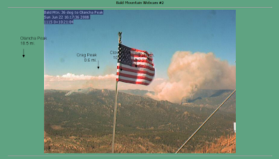
This image was grabbed from Fremont Peak Cam in the east side of the Salinas Valley June 22, 2008.

.
Labels: 2008 Fire Season, Big Sur, California Firestorm 2008, Gallery Fire
Northern California Operations Fire Report
Samples from the document are from various fire managers found in ICS-209 Incident Reports;
What you are reading below is exasperation across the board. In a normal environment fire managers possess the ability to call upon resources and count on them being filled.
"Our lack of adequate resources to staff the additional 6 lightning fires on the unit has required us to focus our attention toward containment as opposed to control. Strategy has been to complete line constuction/containment as resources allow. Fires have been prematurely placed in patrol status in order to contain other unmanaged incidents."
"Poor access and limited equipment available. SHU incident 1-1 (Popcorn)in the area of Popcorn WSA has burned onto Lassen Modoc Unit and is an immediate threat
"LACK OF CRITICAL RESOURCES. IMPACT OF HIGH VISIBILITY ALONG THE HWY 50 CORRIDOR ADJACENT TO THE SOUTH FORK OF THE
"Our lack of adequate resources to staff the additional 6 lightning fires on the unit has required us to focus our attention toward containment as opposed to control. Strategy has been to complete line constuction/containment as resources allow. Fires have been prematurely placed in patrol status in order to contain other unmanaged incidents."
"Multiple fires MINIMAL STAFFING with evacuations in place or imminent: Flynn Creek is 1400 acres, 5% contained and threatening homes; Orr Springs is 200 acres threatening 1 commercial property and approximately 25 residences; Cherry is 180 acres, evacuations of 40 residences and 0% containment; Table is approximately 1000 acres and threatening residences. Heavy resource drawdown is leaving 2/3 of the fires unstaffed. Inaccessible, steep terrain. No Unit coverage, all stations are unstaffed."
"Two new fires were detected today. Unstaffed fires continue to grow. Accessibility is a problem along with difficult terrain, rolling material, snags and poison oak. Approximately 50% of 36 fires are in the Trinity
"The Lime Complex is comprised of approximately 68 fires ranging in size from one acre to over 400 acres. A number of fires are located in remote areas with steep terrain and limited, or no access. We continue to concentrate on fires that have been initial attacked versus those fires which have not been attacked, and choosing winnable initial attack, or extended attack actions. We are determining resources assigned to each staffed fire. Projections in the 24 to 72 hour time frames show the community of Hyampom may be surrounded by fire in the 24 hour time range with all ingress and egress severed. A similar forecast holds for the Town of
"Fatigue and lack of resources are compromising control objectives. The Gov and Westville fires may burn together and make a significant up-canyon run. The communities of Foresthill, Baker Ranch and
Labels: 2008 Fire Season, California Firestorm 2008
California Wildfires Map
The following is a list of significant, active fires in California. Please use the information on these pages only as a reference.
View Larger Map
Labels: 2008 Fire Season, California Firestorm 2008
Gov. Schwarzenneger Says Put These Fires Out
Gov. Schwarzenegger Directs Coordinated Firefighting Efforts and Resources to Combat Wildfires
Governor Arnold Schwarzenegger has directed the California National Guard and all state firefighting resources to aggressively combat numerous wildfires across California. Today he was briefed on the Wild Fire incident and the status of firefighting efforts statewide at the Lagoon Valley Regional Park in Fairfield, the base camp for the Wild Fire incident in Napa and Solano Counties.
Conditions of summer rain, wind and lightning along mountains and deserts over the last few days have caused hundreds of small fires across the state. On Saturday, the Governor ordered the California National Guard (CNG) to mobilize a total of six helicopters and one RC-26 remote sensing platform to assist in combating the wildfires in Northern California. Five National Guard helicopters with water dropping capabilities are being deployed today to support firefighting efforts; two from Nevada, two from Oregon and one from the California Guard. These are in addition to the six CNG helicopters, RC-26 imaging aircraft and two Modular Airborne Fire Fighting Systems (MAFFS) aircrafts that were requested on Saturday and were in place in California today.
The Governor's Office of Emergency Services (OES) continues to coordinate firefighting resources from across the state, including:
OES Fire Branch has opened their Fire Emergency Operations Center on a 24-hour basis to support firefighting efforts.
Hundreds of strike teams with fire engines and firefighters from local agencies have been dispatched and most are battling the most significant blazes.
The five new Type 3 wildland fire engines unveiled by Governor Schwarzenegger earlier this month are actively involved in mutual aid firefighting efforts in Northern California. These engines are from San Diego and Riverside Counties.
Special Operational Area Satellite Information System (OASIS) trailers have been sent to the Indians Fire in the Los Padres National Forest in Monterey County. OASIS trailers provide communication capabilities to emergency responders in remote parts of fire-damaged areas, where normal telephone and power sources have been disrupted.
CAL FIRE has deployed the following fire and rescue resources and activated the following personnel:
4,313 CAL FIRE personnel
372 fire engines
109 crews
14 air tankers
37 bulldozers
31 helicopters
43 water tenders
The following significant fires continue to burn in different parts of the state today:
Northern California
The Wild Fire incident, located in the Green Valley area of Napa-Solano Counties, has burned 3,750 acres and is 40 percent contained. There is one residence and one outbuilding destroyed.
The Walker Fire is located near Indian Valley Reservoir in Lake County. This fire is 3,500 acres and zero percent contained with 35 residences threatened.
The Lime Complex Fire is located in Shasta-Trinity National Forest, Trinity County-five miles south of Hyampom. The fire is currently at 4,000 acres and is zero percent contained. There are 1,200 residences, two commercial buildings and 300 outbuildings threatened. One commercial property has been destroyed.
In the Shasta-Trinity counties, over 130 fires are burning at a total of 5,000 acres, threatening 13 communities. Eastbound Highway 299 may be impacted by these fires.
The Quarry Fire is located near the base of San Bruno Mountain in Brisbane, San Mateo County. This fire is 300 acres and 100 percent contained.
Fires are burning in various locations throughout Humboldt County. The fires are currently at over 900 acres, including four new fires that started today. Five residences are threatened.
In Butte County, fires burning near the communities of Concow, Magalia and Paradise total 1,397 acres and are five percent contained. 200 residences are threatened.
110 fires, including 20 new fires discovered yesterday, are burning in Mendocino County, totaling 7,625 acres. 17 of these fires are contained. Four of the fires are greater than 1,000 acres. Over 525 homes are threatened.
Central California
The Basin Complex Fire is located near Big Sur in Monterey County. The fire is 2,000 acres and 10 percent contained. 500 residences, 20 commercial properties in the Big Sur area are threatened.
The Indians Fire is located in the Ventana Wilderness in the Los Padres National Forest in Monterey County. The fire is currently 57,158 acres and is 58 percent contained. Two residential structures and 13 outbuildings have been destroyed. 1,063 homes, 265 outbuildings and five commercial properties remain threatened. There are nine firefighter injuries reported to date as a result of this incident.
For more information on these fires, go to www.oes.ca.gov or http://cdfdata.fire.ca.gov/incidents/incidents_current.
On May 9, 2008, the Governor issued Executive Order S-03-08, which boosted the state's preparedness for wildfire season and directed the California Department of Forestry and Fire Protection (CAL FIRE) to immediately mobilize critical firefighting resources and personnel to save lives and homes statewide.
Labels: 2008 Fire Season, California Firestorm 2008
Clover Fire Perspective & Post Of The Year Candidate
Well said!
Labels: 2008 Fire Season, California Firestorm 2008, Clover Fire
June 22, 2008
Satellite Images of California Firestorm 2008
Note the Clover Fire in the bottom right and the Gallery Fire below Monterey Bay. The Lime Complex in Trinity County upper right and the numerous fires burning in Lassen, Butte, Amador and neighboring counties. In the center of the image is the Mariposa Complex. Barely visible is the remnant of the Wild Fire in Napa County. More than 700 fires are burning in north and central California. Many fires are unmanned, many manned fires are woefully understaffed presenting a danger to firefighters and surrounding communities.


.
Labels: 2008 Fire Season, California Firestorm 2008
Safe To Say They Lost The Clover Fire

I've covered the Clover Fire and have watched this FUM to suppression fire deteriorate. Best of luck fellas, that's nasty country to fight fire in.

.
Labels: 2008 Fire Season, Clover Fire
California Firestorm 2008 Rages On
Inciweb.org is the Federal Government's incident information website and a repository for information submitted by fire managers for public consumption.
(Note: Inciweb has been down for most of the day)
In the alternative Wildlandfire.com is a great resource for those who want to follow the action statewide, near real time.
Cal Fire's incident page is generally updated with (sanitized) information every shift.
Here is their list of lightning caused fires in the north State.
Summary of Fires by Unit
Siskiyou Unit: 8 fires reporting minor acreage
Humboldt Unit: 50 fires for more than 200 acres
Mendicino Unit: 60 fires mapped, more than 30 additional observed; fires range in size from 1-125 acres
San Mateo-Santa Cruz Unit: 15 fires up to 2 acres in size
Amador-El Dorado Unit:8 fires for approximately 75 acres
Nevada-Yuba-Placer Unit: 7 fires all less than 1 acre each.
Butte Unit: 24 fires for a total of more than 300 acres.
Tehama-Glen Unit: 34 fires for a total of 550 acres.
Shasta-Trinity Unit: 62 fires up to 50 acres in size.
Sonoma-Lake-Napa Unit: 5 fires with 4 contained and one burning near Napa West of Fairfield at 300 acres.
Lassen-Modoc Unit: 27 fires for a total of 25 acres.
Tuolumne-Calavares Unit: 16 fires for a total of 140 acres. Currently the counties of Tuolumne and Calaveras are experiencing heavy smoke in low lying areas due to fires caused by heavy lightning activity yesterday.
Madera-Mariposa-Merced Unit:15 fires reported. The Cunningham Complex (5 fires total) are burning 3,150 acres total, the Stumpfield Fire is burning 2 acres, the Indian Peak Fire is burning 60 acres, and the Oliver Fire is burning in the Sequoia National Forest. The Sequoia National Forest has reported 25 fires.
Many Fires like the Gallery Fire in Big Sur have no current updates from the government sites. I'm preparing a post with an update from various sources including blog search, old media outlets, message boards, Flickr, Youtube, CHP and official incident reports.
Check back later!
Labels: 2008 Fire Season
Significant Challenges For California Firefighters
Resources for these fires are being pulled from the (55,000 acre) monster Indians Fire burning on the east side of the Ventana Wilderness. Indians Fire management may postpone some firing operations as resources are pulled for initial attack and structure protection on these smaller fires.
The 3,000 acre Brown Fire in San Benito County is burning in grass rangeland south of Hollister. The optimistic narrative in the ICS-209 makes it sound like this one will get pinched off by the 5 engines they were given. That's an optimistic viewpointconsidering the weather near the Pinnacles and lack of resources available.
In Gilroy the Hummingbird Fire is forcing evacuations of residents along Day Road. Scanner chatter indicates incoming crews are setting up for day and night shifts. No ICS-209 reports are available at this time.
Crews in the Napa Valley near Suison and Green Valley are battling the 3,000 acre Wild Fire. Fire management estimates this fire may take four days to contain provided resource requests are filled. One structure has been destroyed as the fire rips through 20 year old stands of mature chaparral and oak woodlands. As I write this Tanker 910 is requested by air attack.
Multiple fires ignited in Butte County threatening communities of Paradise, Forest Ranch, Cohasset, and Magalia. Most of these fires are smaller, unnamed events for the time being.
In Tuolumne County in the Stanislaus River Canyon below Big Trees State Park and Dorrington firefighters are keeping watch on multiple lightning caused fires. While these fires do not present a current threat to life and property they require a vigilant watch. These crews are not allowed to respond to other areas at the moment.
Shelton Ridge near Lyonsville east of Red Bluff in Tehama County is ground zero of numerous lightning caused fires, many under 1 acre, some as high as 15 acres.
In Trinity County the Lime Complex involves a number of lightning caused fires. The main fire has consumed 1,500 acres manned by 600 fire personnel. There are frankly too many fires to name.
The Forest Service is gaining an upper hand on the 4,000 acre Clover Fire in the Sequoia National Forest. For the time being these crews are pinned down for mop up activities.
This is the widest spread of resources I can recall. Thankfully Southern California has been quiet.
View the Wild Fire from the Mt Diablo web cam.
.
Labels: 2008 Fire Season
June 21, 2008
Clover Fire, They'll Fight It Now
Hikers on the Pacific Crest Trail are being rerouted, away from flames and fire suppression activities. The fire is burning generally eight miles north of Kennedy Meadows in the So. Sierra Wilderness.
Take a look at this webcam view of the Clover Fire.
Labels: 2008 Fire Season, Clover Fire
Lime Complex; All Hands To California's North Coast
Redding Smokejumpers responded before nightfall last evening and are deployed on at least three of the fires.

These fires and others could burn all summer. The initial ICS-209 filed includes the following information;
Projected incident movement/spread 12, 24, 48, and 72 hour time frames:
12 hours: DOUBLE IN SIZE
24 hours: QUADRUPLE IN SIZE
48 hours:
72 hours: SIGNIFICANT GROWTH EXPECTED
Significant events today (closures, evacuations, significant progress made, etc.):
RECEIVED DRY LIGHTNING IN LATE AFTERNOON HOURS. 40 IDENTIFIED NEW STARTS ON THE FOREST, 29 ON THE HAYFORK DISTRICT. LIGHTNING CONTINUED THROUGHOUT THE NIGHT ON THE FOREST.
Values at Risk: include communities, critical infrastructure, natural and cultural resources in 12, 24, 48 and 72 hour time frames:
12 hours: LYMEDYKE LOOKOUT, SOUTHFORK OF TRINITY RIVER WATERSHED AND FISHERIES. ASSESSMENT OF STRUCTURES THREATENED AND OTHER VALUES AT RISK ONGOING
99 degrees in the region yesterday!
View Larger Map
.
Labels: 2008 Fire Season, Lime Complex
June 20, 2008
First Day Of Summer Brings Devil Weather
Firefighters in Watsonville fighting the Trabing Fire will see temps. in the mid 90's.
Heat exhaustion is a consideration.
A Red Flag Warning has been issued by the National weather Service for south and central coast counties including Santa Barbara, Ventura and San Luis Obispo.
In the north part of the state there are no formal Red Flag Warnings but common sense says these are uncommonly hot and dangerous conditions.

Use caution my Brothers. Listen to your crew captains.
Labels: 2008 Fire Season
Trabing Fire; Thousands Flee Path
Trabing Fire Map
View Larger Map
Trabing Fire Video shot by local residents.
Steady camera work, Cal Fire Air Attack at work!
This video looks like it was shot from near the Summit Fire grounds or from Mount Loma Prieta.
.
Labels: 2008 Fire Season, Trabing Fire
June 18, 2008
Indians Fire A Zaca Fire Redux?
Recall the Zaca Fire when the fire command lost it after nearly pinching it off at 35,000 acres? As I recall it was the same ICS team, CIIMT2 in control when the fire squeezed through a small pass and exploded to the S/E claiming another 200,000 acres before it was stopped in Ventura County.
So far 9 firefighters have been injured on the Indians Fire,at least 3 of the injuries were the result of a burnover that required hospitalization of at least one firefighter.

Now that the fire is firmly established in a Wilderness designated area don't look for this to be a priority. Like the Zaca, and countless other such fires including the Marble-Cone Fire that burned 177,000 acres in 1977 (only miles from the Indians Fire scene) the Forest Service will milk this baby for awhile.
Example; from the ICS-209 tonight
Given the current constraints, when will the chosen management strategy succeed?
"A projected date will be provided upon the completion of long term strategy planning."
It's understandable they want to pad the budgets, it's cultural within the Forest Service but my thoughts anymore are with the younger firefighters who really believe they are there to put the fire out. Firefighter retention within the Forest Service is a big problem. Forest Service firefighters are bolting to Cal Fire, not only for pay and better hours but to actually fight fire instead of babysitting dead divisions on prolonged events.
Draw your own conclusions. Follow the Indians Fire at Inciweb.
More information from the Incident 209 (via email and NIFC pdf)
-------------------------------------------------------------------
*The incident remains under unified command with CIIMT2 (Molumby, IC), Cal Fire (Hutchinson, IC), and Fort Hunter Liggett (Crum, IC). Long range strategic plans continue to be developed. Perimeter calculations are based on the primary control line. The correction to the number of residences destroyed in blk. 25 is due further assessment performed during todays operational period.
Short Location Description (in reference to nearest town):
*Ventana Wilderness, West of Fort Hunter Liggett
Start Date
*06/08/2008
Expected Containment Date:
(None specified)
Today's observed fire behavior (leave blank for non-fire events):
Primarily backing with some moderate slope runs. Single and group tree torching were observed.
Actions planned for next operational period:
Continue indirect line construction. Prepare for future firing operations. Patrol and hold line. provide structure protection.
Total personnel assigned:
2,400 +
 Image, Rapidfire
Labels: 2008 Fire Season, Indians Fire
