August 31, 2009
Tanker 979 (747 Supertanker) Maiden Fire Drop
The tanker offers up 20,000 gallons per load. Consider that Tanker 910, the DC-10 Supertanker delivers 12,000 gallons.
There is a new weapon over California fires and it is about time.
Labels: 2009 Fire Season, DC-10 Supertanker, Station Fire, Tanker 910, Tanker 979
Oak Glen Under Siege
InciWeb has details.
The Oak Glen Fire is under the jurisdiction of CalFire. It started on Sunday August 30, 2009 at 1:45 pm in the hills south of Potato Canyon Road and Oak Glen Road about 4 to 5 miles north of Beaumont and Banning. Mandatory Evacuations are in effect for the south and southeast portions of Oak Glen and voluntary evacuations for the remainder of Oak Glen.
Basic Information
Incident Type Wildfire
Cause Under Investigation
Date of Origin Sunday August 30th, 2009 approx 01:45 PM
Location 4-5 miles north of Beaumont
Incident Commander Jeff Veik
Current Situation
Total Personnel 1,024
Size 1,000 acres
Percent Contained 25%
Fuels Involved Heavy chaparral, oak woodland and mixed pines.
Fire Behavior
Today, firefighters face high temperatures and low humidity, rugged terrain, and very dry and flammable vegetation that in many instances has not burned since 1924. Fire is fuels and topography driven.
Significant Events
Aggressive fire fighting and air attack made good progress on the fire. Poor humidity recovery and heavy, old fuels have promoted active burning last night and significant increase in acreage. Firefighters are on the line today constructing containment line around the fire with the help of the hand crews and the bulldozers. Coordination with Sheriff on evacuation continues as needed.
Planned Actions
Structure protection, construction of control lines on all divisions.
Growth Potential High
Terrain Difficulty Extreme.
Remarks
Road Closures-- Oak Glen Road from Chagall Street to Wildwood Canyon Road. Large animals can be taken to the Yucaipa Equestrian Center 13273 California Road. For animal emergencies related to the fire, call San Bernardino County Animal Control 1-800-472-5609. 1024 personnel, resources assigned: 87 engines, 6 water tenders, 41 hand crews, 8 dozers, 10 helicopters, 6 airtankers, one 747, and Martin Mars and DC-10. One home damaged.
Current Weather
Wind Conditions 14 G16 mph W
Temperature 100 degrees
Humidity 6%


Labels: 2009 Fire Season, Oak Glen Fire
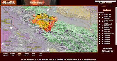
Station Fire Path; Where's It Headed?
According to GeoMac the fire appears to have crossed Highway 2 north and east of Mt Wilson. The USFS Google Earth kml overlay lags GeoMac but both mapping services indicate where the fire is headed on its eastern front.
As it looks the fire is headed towards Crystal Lake and Highway 39.
 The image below is from Google Earth using the USFS kml overlay that mimics the GeoMac heat detection software.
 The views below are pointing west at the advancing fire from above Crystal Lake.

NorthTree Fire International has put together this map of the fire perimeter. NorthTree is THE fire mapping service.
View Larger Map
Labels: 2009 Fire Season, Station Fire
Station Fire Satellite Imagery From 8/30

 Click the images to enlarge. Note the enhanced fire perimeter outline in the image above.
 Latest imagery from GeoMac.
Labels: 2009 Fire Season, satellite fire photos, Station Fire
Tanker 979, The 747 Supetanker Expected Over Fires Today
Here is a promo video of Tanker 979 over the desert near Tucson. The 747 supertanker has a payload of 20,000 gallons. Tanker 910, the DC-10 supertanker delivers 12,000 gallons of water or retardant.
I can't wait to see the first images of this aircraft in operation over a fire.
Labels: 747 Supertanker, Station Fire, Tanker 910, Tanker 979
Station Fire Explodes on Eastward Track
The eastern progression may be allowed to run towards Pearblossom with firefighters laying freeway sized dozers lines at some point in the forest. Dietrich will guard against runs to the west and will try to prevent the fire from doubling back to the south into Sierra Madre. In my opinion this is the biggest danger looking at the map.
 WildlandFire.com has very good coverage of all new and ongoing wildfires in the state.
InciWeb publishes information directly from the incident command team. The data is updated twice daily.
Labels: 2009 Fire Season, Station Fire
August 30, 2009
Two Die In The Line Of Duty On The Station Fire
What makes this tragedy more sad is the two fallen firefighters may be brothers.
Deepest condolences to the family and friends of the fallen firefighters.
Labels: 2009 Fire Season, LODD, Station Fire
49 Fire Burning Multiple Structures in Auburn
The image below represents the approximate fire perimeter. Structures have been reported burned on Locksley lane at Highway 49 as well as on Shale Ridge Lane. Notice the airport in the image below. Air Attack is centering their current suppression efforts near the large water tanks just north of the end of the runway.
There is reason to believe structures to the north of the water tanks are involved.

Update: 49 Fire in Auburn holding, though multiple structures still involved within perimeter, VLAT {very large air tanker} (747 Supertanker) canceled.
Labels: 2009 Fire Season, 49 Fire
Mt Wilson in Path of Station Fire

Station Fire, More Google Earth Views, Map, Scanner Link

 For anyone that wants to listen to Station Fire air attack communications listen here.
Choose the channel from the menu that focuses on LA County Sheriff, Fire, and EMS.
The current status is: Scanning BRUSH FIRE
View Los Angeles County fires north of La Canada Flintridge, Altadena in a larger map
Labels: 2009 Fire Season, Station Fire
Station Fire Satellite Imagery

Please click the images to expand
 Compare the current size of the Station Fire to the (now contained) 90,000 acre La Brea Fire burn to the west above Santa Barbara.
Labels: 2009 Fire Season, satellite fire photos, Station Fire
Station Fire Commander Called Out Of Retirement to Head Effort

Dietrich's team was criticised by some during the Basin Complex in Big Sur for leaving many homes and one monastery to their own fate but he won't do that with the eyes of the Los Angeles media on top of the fire.
With resources rightfully focused on structure protection the fire will move north and east as fuel, topography and weather dictate. As the fire moves towards Acton Dietrich's firefighters will be well positioned to save homes that are savable.
This fire is an odd egg. It's a Socal monster fire with no wind driving it.
Nearly every major fire in Southern California in recent years has been wind driven. The Station Fire is feeding on drought parched fuel beds that have not burned for fifty years or more.
Where will it go? I expect this acreage to double from here with personnel working on this fire for weeks after containment. The danger is the longer there is open flame the closer we get to October when the Santa Ana winds come howling off the high desert.
-------------------------------------------------
As of this morning the Station Fire is now over 35,000 acres with minimal containment. The west head of the fire looks like it wants to merge with the 2008 Marek and Sesnon burns. To the north the fire heads towards the town of Acton in the Santa Clarita Valley. The eastern head of the fire moves unabated deeper into the Angeles National Forest.
Labels: 2009 Fire Season, Station Fire
August 29, 2009
Station Fire: Maps, News Links, More
The LA Times as usual does a fantastic job of covering the fires as well.
Of course Twitter Search is also abuzz with local insights and also where I found this time lapse video.
Time Lapse Test: Station Fire from Eric Spiegelman on Vimeo.
The fire has consumed 20,000 acres and has burned 3 homes near La Canada and dozens of cabins in the Angeles National Forest within the San Gabriel Mountain range.
4,000 have been evacuated so far as the fire works its way towards the town of Acton near Santa Clarita. With a 360 degree flame front in steep, inaccessible terrain that has not burned in over 50 years firefighters are severely challenged.
One firefighter has a heat related injury and three civilians were injured in the Big Tujunga Canyon area trying to defend their home.

Information gleaned from the ICS-209
Values at Risk:
12 hours: Northern portions of the City of La Canada-Flintridge, Mount Lukens Communications Facility, Edison 220 Kv Powerlines, Edison 33Kv Powerlines to Mt. Wilson, Gould Sub-station, NASA Jet Propulsion Laboratory, Arroyo Seco Residences, and Altadena.
24 hours: Northern portions of the City of La Canada-Flintridge, Altadena, Mount Lukens Communications Facility, Edison 220 Kv Powerlines, Edison 33Kv Powerlines to Mt. Wilson, Gould Sub-station, NASA Jet Propulsion Laboratory, Arroyo Seco Residences, ANF Clear Creek Fire Station, Clear Creek School, and the Mount Wilson Communications Facility/Observatory.
Labels: 2009 Fire Season, Station Fire
Station Fire Maps, Google Earth Views
I grabbed the images below from Google Earth using the USFS kml files from the MODIS Active Fire Program site.


 Looking up at the San Gabriel Mountans from between Montrose and San Gabriel.

Labels: 2009 Fire Season, Station Fire
Station Fire; Angeles Crest

I took this information straight from InciWeb. Follow the Station Fire on Twitter
Basic Information
Incident Type Wildfire
Cause Under Investigation
Date of Origin Wednesday August 26th, 2009 approx 03:30 PM
Location Los Angeles River Ranger District / Angeles National Forest
Incident Commander Michael Dietrich
Current Situation
Total Personnel 751
Size 5,500 acres
Percent Contained 5%
Estimated Containment Date Tuesday September 08th, 2009 approx 06:00 PM
Fuels Involved
Very heavy fuels of ceanothus (sp), chamise, scrub oak and manzanita across the entire fire area, 15 to 20 feet in height with Big Cone Douglas Fir in the drainage bottoms. Fuels have not experienced any significant large fire activity in the past 40 years.
Fire Behavior
Friday behavior was very active to extreme, with rapid rates of spread and flame lengths up to 80 feet. There is a potential for Saturday's fire behavior to be similar to Friday. Around noon Saturday, after the inversion has lifted, expect actively spreading fire with up slope runs. Spotting may occur from 1/4 mile up to 1/2 mile.
Significant Events
Mandatory Evacuations as of early Saturday morning include Starlight Crest Drive north to Green Ridge Court, including Forest Green Drive, two, Big Briar Way at Haskel, and third, Donna Maria Lane, Indian Drive, Hacienda Drive, Alta Canada Rd., North of Linda Vista, La Canada Blvd. north of El Vago Street. Evacuation Center: La Canada High School, 4463 Oak Grove Drive, La Canada, CA. Angeles Crest Highway remains closed.
Outlook
Planned Actions
Prepare and protect structures when and where necessary. Construct handlines and dozer lines.
Growth Potential Extreme
Terrain Difficulty Extremely steep and inaccessible
Remarks
1800 homes threatened. 27 commercial properties and 52 other stuctures threatened.
Current Weather
Wind Conditions 5-8 mph E
Temperature 80 degrees
Humidity 30%
Labels: 2009 Fire Season, Station Fire
August 28, 2009
Yosemite Fire: Prescribed Burn Gone Bad
 ......and the idea was poorly thought out from the start. Middle of Summer, heat wave forecast. What could go wrong?
It is called the Big Meadow Fire burning in the Foresta area. Wildland Fire guys are updating details. National Parks Traveler has some information as well.
Planning prescribed fires in Yosemite in the Summer is a dumb idea. Smoke hinders valley views and causes delays on the few roadways in the park.
It's also irresponsible to play with fire in the middle of the tourist season.
So far 2,000 acres have burned, roads have closed, cabins are threatened, businesses are affected and most importantly firefighters and air tanker pilots are put at great risk chasing this mistake.

I'm all for controlled burning but there is a season for this, not the middle of the Summer, near the entrance of a National Park.
Labels: 2009 Fire Season, Big Meadow Fire, Yosemite
August 23, 2009
Athens Greece Fires in Video
In our country we rightfully preach safety as paramount. To that end we rarely see civilians actually manning fire hoses or beating flames with towels and branches. There is something very refreshing seeing citizens taking matters into their own hands to save their homes. Notice the neighbors helping firefighters man fire hoses and the woman in the alley beating down flames with a stick.
Something else we don't see much of in the US is fire photojournalism. Photo Journalists are always kept back by fire officials. Consider the two big fires in California this year, the 90,000 acre La Brea Fire and the 7,000 acre Lockheed Fire in Bonny Doon. I don't recall any close up images of flames or firefighters. I'm not knocking current policy, only stating fact. It's all about safety and control here.
Labels: Greek Wildfires
New Greek Fires Satellite Imagery (Aug 23)
 Click image to enlarge
From NASA Rapifire
Labels: Greek Wildfires
Greek Fires Video of Air Assault
Notice in this video how close to the ground these aircraft get. Montanan David Jamsa lost his life last week flying in a similar aircraft in a fire near Reno.
Follow the fires at Twitter #grfires.
Labels: Greek Wildfires
August 22, 2009
Greek Fires Satellite Imagery
'I fear that unless the fire is contained during the night we will see nothing left standing by sunrise,' said Spyros Zagoris, the Mayor of Marathonas. Story
The fires are being pushed by gale force winds and aircraft was pulled for the night. Hopefully civilians have fled the region.
CNN has more.
 Click images to enlarge
These fires are reminiscent of the wildfires that killed 65 people in Southern Greece in August of 2007. I blogged those fires to a great extent including posts here and here.
Greece is no stranger to wildfire but the country is poor by Western standards. The military is called on to fight the larger blazes. Homeowners do their best to protect their homes but in 2007 most of the fatalities were due to civilians staying near their homes instead of fleeing at the first hint of smoke.
In 2006 and 2007 the Russians sent a couple of their supertanker aircraft to assists the Greeks. The entire EU offered assistance in 2007.
Note:
Για Έλληνες φίλοι μας, μπορεί να σας όλα να είναι ασφαλή και οι τρομερές πυρκαγιές πάει μακριά.
Labels: Greek Wildfires
La Brea and Lockheed Fires Satellite View (From 8/13)

Labels: 2009 Fire Season, La Brea Fire, Lockeed Fire
August 21, 2009
Tanker Pilot Dies In Nevada Wildfire
This (Hoyt) fire is in a remote area east of Dixie Valley, about 20 miles north of U.S. Highway 50. There are three "line cabin" structures reported in the area, used by local ranchers.
From the BLM release;
Reno, Nev. — The Bureau of Land Management (BLM) has identified Dave Jamsa as the pilot who was killed yesterday after his single-engine air tanker (SEAT) crashed while flying fire suppression operations on the Hoyt Fire.
Jamsa was an employee of Minuteman Aerial Application Inc., which is based out of Missoula, Montana, and was an employee of the company working a contract out of the BLM's McDermitt SEAT base.
Condolences to the family, friends and co-workers of Dave Jamsa.
Labels: 2009 Fire Season, LODD
August 15, 2009
Lockheed Fire Wrapping Up
Two outbuildings destroyed, a few thousand acres, no serious injuries. There was some hand to hand combat by Cal Fire and cooperating agency engine crews, dozers, hand crews, helicopter and air tanker pilots that saved dozens of homes in and near Bonny Doon, Davenport and Swanson.
 Note: I think it's funny that Fox News and the other news agencies are blasting this fire all over the airwaves as an ongoing emergency. Better really late than never. The Governor is planning a photo op near the fire lines today as well.
Proximity to the populous S.F Bay Area invited the press to the Lockheed Fire and that made it sexy.
The more interesting fire is the La Brea Fire in the Los Padres National Forest, 150 miles to the south.
The closest population center to the 100,000 acre La Brea Fire is Santa Barbara.
2,000 firefighters are sweating on the lines in the national forest and their contributions should be acknowledged.
Another fire burning out of control with the same proximity to the Bay Area as the Lockheed Fire is the Corral Fire near Livermore. Cal Fire surrounded that runner as well with no media fanfare.
Remarkably in all three fires not one home burned!
Labels: 2009 Fire Season, Cal Fire, Corral Fire, Lockheed Fire
August 14, 2009
Lockheed Fire Update
 Image Cal Fire (fair use)
Lockheed Fire Incident Information:
Last Updated: August 14, 2009 6:30 pm
Date/Time Started: August 12, 2009 7:16 pm
Administrative Unit: CAL FIRE San Mateo - Santa Cruz Unit
County: Santa Cruz County
Location: Bonny Doon area - Smith Drainage
Acres Burned: 5,036 acres
Containment 15% containment
Structures Destroyed: 2 outbuildings damaged
Threatened: More than 250 residence are currently threatened in the Swanton and Bonny Doon communities.
Evacuations: Mandatory evacuations for Bonny Doon and Swanton affecting 2,000-2,400 people.
Cause: Under Investigation
Cooperating Agencies: CAL FIRE, Santa Cruz County Sherriff
Total Fire Personnel: 1,548 (570 CAL FIRE)
Engines: 234
Fire crews: 17
Dozers: 22
Water tenders: 17
Costs to date: $ 2.1 million
Major Incident Command Team: CAL FIRE ICT #9
Conditions: Problems and concerns include weather, steep terrain and limited access to the fire perimeter. Strong gusty onshore winds are predicted today, and could push the fire further to the east toward the community of Bonny Doon.
An evacuation center has been established at the Vintage Church at Hwy 1 and Mission. A large animal evacuation center has been set up at the Watsonville fairgrounds and a small animal evacuation center has been established at 7th & Rodriguez.
Phone Numbers (831) 335-0378 (Lockheed Fire Information )
Information from CalFire.

Labels: 2009 Fire Season, Lockheed Fire
La Brea Fire Estimated Over 100,000 Acres
Look at the image below. The Zaca burn is the purple outlined area south of the La Brea. You will note the La Brea has actually entered the two year old Zaca vegetation and appears to be established in the old burn.
 What can we expect from here. If the current weather pattern persists we could see the Le Brea continue its E/SE trajectory and burn all the way to Highway 33, just like the Zaca Fire. This outcome is weather dependent, little done by the fire command so far has managed to stem the rapid growth.
Please follow my Twitter updates here.
Labels: 2009 Fire Season, La Brea, La Brea Fire, Zaca Fire
La Brea Fire Pushing East and Southeast
Predicatively the La Brea wildfire is moving now with the prevailing winds. This wind and terrain driven fire will continue to move east and southeast through unburned areas of the San Rafael Wilderness within the Los Padres National Forest.
The advertised acreage is just under 67,000 but figuring infills from firing operations and activity to the east ans S/E and the fire is probably closer to 80,000 acres at the moment.
GeoMac is not real time but it is the closest tool outside observers have.
Notice how the south edge of the fire is bumping along the 2007 Zaca burn. The guys are doing a great job of utilizing the repaired 2007 dozer lines and the Sisquoc Creek/River drainage.

The Pincha-Tulley team is keeping cost figures from the public. In the past this information was passed along to the public through Inciweb. I suggest they want to downplay containment costs as policy now.
For those wondering like me, where are the supertankers? That 20,000 gallon 747 is just sitting out in the Mojave desert like a pretty bridesmaid waiting to get the call.
----------------------------------------------------------------
Updated image, noon today. In the heat detection image below the software indicates numerous spots to the west, east and south. With the afternoon heating and gathering winds these spot fires will challenge firefighters who are already tired.
 (Click image to enlarge)
Labels: 2009 Fire Season, La Brea, La Brea Fire
August 13, 2009
Lockheed Fire Google Earth Images


Labels: 2009 Fire Season, Lockheed Fire
Lockheed Fire
This area has not burned in decades. Terrain is steep and vegetation varies from virgin redwood stands to thick manzanita and pines. FEMA has taken note and issued a "Fire Management Assistance Declaration" due to the proximity of the fire to the Lockheed rocket development facility in the fire's path.
The fire has burned close to 2,000 acres in the first 12 hours.
View Santa Cruz Mountains wildfires in a larger map
Update: 11:00 am
The Lockheed Fire has burned 3,000 acres and is spreading in all directions. Zero percent containment with spotting deep into Big Basin Redwoods State Park according to the image below from GeoMac.

Labels: 2009 Fire Season, Lockeed Fire
August 12, 2009
La Brea Fire Meets Zaca Fire Perimeter

So what happens now? We know the Zaca Fire dozer lines are still in place so firefighters can anchor off those. Sisquoc Creek also offers a key potential fuel break for firefighters. If the La Brea blaze spots over and into the Zaca burn it will find two year old growth, a far cry from the 80 year growth it is feeding from currently.
I expect the fire to keep moving east as well as west. At this pace anything north of the Zaca perimeter that is green in the image above will burn. I would be surprised if this fire is held to under 100,000 acres.
Labels: 2009 Fire Season, La Brea, La Brea Fire, Zaca Fire, Zaca Fire Map
You Order, You Pay. La Brea Fire May Usher In New Era Of Interagency Cooperation
"At 1200 the fire entered into Unified Command with Cal Fire because the fire threatens state DPA. The threat is from a slop over off Sierra Madre Road into Foothill Road located in Branch Four. There is a cost share agreement with Cal Fire for “you order you pay”. The slop over Sierra Madre Road in Moon Canyon has the potential to go to the valley floor. Evacuation order issued for the 14 threatened residences on Foothill Road and evacuation warning issued via reverse 911 to the 104 residences in Cottonwood Canyon."
Mike opines;
"You order you pay? I think that means the USFS is billing CalFire for any actions that CalFire "orders". Such as the Martin Mars. Who takes responsibility when poorly managed Fed land blows up in a massive fire and threatens private land on the other side of the fence? Evidently CalFire will be billed for suppression actions at the "interface". The old co-op suppression agreements are burning up along with the landscape."
Mike may be right, apparently if Cal Fire orders in equipment they will have to pay the entire cost billed by their contractors, even if sloppy work by the Feds requires a state response. I'm not saying the La Brea incident is mismanaged, not suggesting this at all.
Are we entering an era of a leaner, meaner USFS? Getting budget minded all of a sudden? Ms Pincha-Tulley did not just pull this rabbit out of her hat, no this came from a policy change.
As I understand the current policy if a fire runs into another jurisdiction, that jurisdiction must pay their own freight, nothing new here. What is new is the direct wording. I have never heard that phrase before.
I have a feeling Pincha-Tulley wants the 747 and DC-10 Supertanker, (Tanker 910) on scene but doesn't want to pay. Typically, once aircraft are above a fire air attack keeps track of what drops go where. Say a tanker drops 40 loads, 20 on state land and 20 on Fed land. The drops are billed accordingly.
More often in practice the drops are blurred, whereupon the bill is absorbed by one party or another, or a good guess at a split is attempted. That era may be over. It appears now that if Cal Fire orders equipment they bear the brunt of the costs.
Cal Fire could get tough by calling up the tankers, order drops on their designated area of operation and send them home.
Will we need for an arbitrator at incident bases in the future. The "Incident Legal Office", or ILO would be inexpensive compared to costs of overhead, equipment, personnel, food, lodging and transportation.
Worth keeping an eye on, let's see how this plays out.
Labels: 2009 Fire Season, 747 Supertanker, Cal Fire, DC-10 Supertanker, politics, USFS
August 10, 2009
Zaca Fire Remembered
With the La Brea blaze about to touch the edge of the Zaca burn it is appropriate to reacquaint ourselves with the fire potential of this region.
Labels: Zaca Fire
La Brea Fire Maps
The first view is looking west from over the Carrizo Plain with Santa Maria and the Pacific Ocean in the background.

The next image takes a look at the La Brea Fire perimeter from the North.

This image shows a perimeter perspective from overhead. As you can see there is a 360 degree active flame front.

Perimeter map of the fire from Inciweb.

This fire is much larger than the published 10,500 acres mentioned 24 hours ago. Without access to current ICS 209 reports we have to wait on the Pincha-Tulley crew to update Inciweb.
This will be an interesting incident to observe, the combination of Wilderness designation and lack of firefighter access presents an unusual combination for a California fire.
Labels: 2009 Fire Season, Google Earth, La Brea Fire
