<body><script type="text/javascript"> function setAttributeOnload(object, attribute, val) { if(window.addEventListener) { window.addEventListener('load', function(){ object[attribute] = val; }, false); } else { window.attachEvent('onload', function(){ object[attribute] = val; }); } } </script> <div id="navbar-iframe-container"></div> <script type="text/javascript" src="https://apis.google.com/js/platform.js"></script> <script type="text/javascript"> gapi.load("gapi.iframes:gapi.iframes.style.bubble", function() { if (gapi.iframes && gapi.iframes.getContext) { gapi.iframes.getContext().openChild({ url: 'https://www.blogger.com/navbar.g?targetBlogID\x3d6823728\x26blogName\x3dFirefighter+Blog\x26publishMode\x3dPUBLISH_MODE_BLOGSPOT\x26navbarType\x3dSILVER\x26layoutType\x3dCLASSIC\x26searchRoot\x3dhttps://firefighterblog.blogspot.com/search\x26blogLocale\x3den_US\x26v\x3d2\x26homepageUrl\x3dhttp://firefighterblog.blogspot.com/\x26vt\x3d-1585559697748296898', where: document.getElementById("navbar-iframe-container"), id: "navbar-iframe" }); } }); </script>

May 06, 2009

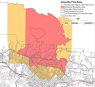
Jesusita Fire Maps and Links

 
Images from Google Earth


Map from KCOY

Local Coverage KCOY.com
Discussion
Search Twitter
Local Video

Labels: , ,


Comments:
Google Map Link
http://maps.google.com/maps?f=q&source=s_q&hl=en&geocode=&q=http:%2F%2Fnorthtreefire.com%2Fgis%2Fintel%2Fjesusita.kmz&ie=UTF8&ll=34.454412,-119.718962&spn=0.054284,0.076132&t=p&z=14

From NorthTree Fire GIS
 
Post a Comment

<< Home