July 16, 2008
High Finances & Wildland Firefighting
The high cost of fighting wildland fires is a pet peeve here. I know I've posted on this before but this was classic Forest Service. I visited a family member working a fire in North Fork California a few years back. I was walking through the incident base and came upon a guy posting an updated fire map for anyone interested.
I asked him where he was from and he said he just flew in overnight from North Carolina. His order was they needed a biologist to the fire pronto. $1,200 one way to San Francisco where he rented a car and drove 4 hours to North Fork. Probably didn't run across any one's mind to fly him into Fresno and grab a cab or have someone from gigantic Forest Service office in Fresno give him a lift. Too logical.
The fire was nearly contained before he came into camp. His uniform never got dirty and since it was his first visit to the Sierra's he probably couldn't offer much in the way of tactics. He told me his job was to help around camp!
This was a perk for him, an overtime lottery win. An open ended trip to the central Sierra Nevada. Fire season is a blank check.
This season more or less started with the Indians Fire May 28 between Camp Hunter Liggett and the Ventana Wilderness. I posted on the final costs of the Indians Fire that burned 81,000 acres at a final cost of $400. per acre.
Two homes burned and 17 firefighters were injured, one seriously.
The Indians Fire was racking up costs early on without private dozers and water tenders. When fires to the north started in mid June private dozers and water tenders were summoned by the dozens. These contractors saved lives and homes. One ICS-209 report I read claimed 47 dozers on the fire, only a few were NOT private.
Contract aircraft, dozers, water tenders, and crews are vital resources and the costs are reasonable all considered.
The fat historically is when a national incident team arrives after a fire is running, grab a map and start planning the path and ending date. Padding budgets by calling in biologists from across the country is proof for me.
On the Fed side it's cultural.
Labels: 2008 Fire Season, California Firestorm 2008, Indians Fire


July 07, 2008
Basin Complex Joins Indians Fire West Perimeter
I'm trusting the GeoMAC software on this one. Basin Fire command has been planning on this for some time. I posted on the possibility here last month.

Labels: 2008 Fire Season, Basin Complex, Big Sur, California Firestorm 2008, Indians Fire, Marble Cone
July 05, 2008
Basin Complex Fire Maps Views July 5
The first image is looking at the north front of the fire from the west. The Basin Complex incident base in Molera State Park is marked.

The image below shows the southern front of the Basin Complex fire. Again the image is viewed from the west.
 This image shows the proximity of the Basin Complex fire to the Indians Fire. This image is cast from the north. Between the two fires lies the Arroyo Seco drainage and the (now) famed Tassajara Hot Springs. The distance between the two fires is less than 2 miles at the closest point.
This GeoMAC image was captured at 4:00 pm PST and shows no current activity on the east front of the fire. The town of Big Sur looks pretty solid this afternoon.

Labels: 2008 Fire Season, Basin Complex, Big Sur, California Firestorm 2008, Indians Fire
July 02, 2008
Indians Fire Final Numbers; 80,000 Acres $40 Million
 Draw your own conclusions. It's shocking really.
Labels: 2008 Fire Season, California Firestorm 2008, Indians Fire
June 30, 2008
Basin Complex Fire Slows, Indians IC Adding Acreage
Today's observed fire behavior:
West Zone: "Fire behavior moderated in all areas with backing and creeping."
East Zone: "Active runs above 2000 ft elevation. Smoldering and creeping in drainages and below 2000 ft."
 Meanwhile on the Indians Fire the plan seems to be "tidy up" by burning out any green areas left on the north flank of the fire. You can see clearly how they are trying to fill in the blanks by intentionally blackening any green (unburned) areas within the fire perimeter.
You will recall from the earliest ICS-209 reports filed over one month ago the current IC predicted the fire would grow to 80,000 acres.
He'll be right.
Meanwhile it appears they experienced some slopover from the operation. We'll see what becomes of that tomorrow.
Labels: 2008 Fire Season, Basin Complex, California Firestorm 2008, Indians Fire
June 28, 2008
Big Sur's Basin Complex a Three Headed Monster
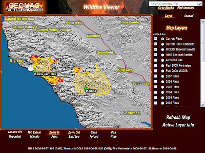
If you look at the path the Basins Complex is taking you can make a case the south flank could run to Nacimiento-Fergusson Road. In this case firefighters could then tie the Basin Complex to the burned areas of the Indians to the east and the Pacific Ocean to the west.
The north flank of the fire should be helped by prevailing N/W winds once they return. The eastern head of the Basin Complex looks like the headache for fire command.
The morning report projected the final size at 170,000 acres. Most of this acreage has to come from acreage gained on its journey east. In order to get to 170,000 acres you have to look out as far as the lower Carmel Valley.

It seems almost inconceivable at the moment to suggest the fire will travel that far but I can't see how else they can get to 170K acres. Residents of lower Carmel Valley will get early clues if they begin seeing bulldozers unloading on the Valley floor to begin constructing or fortifying trails along the first line of ridges running the length of lower Carmel Valley.
These are only my back of the napkin thoughts. For a formal narrative read Sur Coast updates.
Labels: 2008 Fire Season, Basin Complex, California Firestorm 2008, Indians Fire
Officials: Big Sur Fires May Exceed 250,000 Acres
This morning's ICS-209 report for the Basin Complex Fire, now called Basin Complex West includes an estimated final size at 170,000 acres. The Basin Complex West fire will come close to matching the Marble-Cone Fire of 1977 that consumed 178,000 acres on the same ground.
The Indians Fire management team has stated since the start of the fire in May they expect their fire to exceed 80,000 acres. The fire has burned over 60,000 acres so far.
Wikipedia maintains a list of the largest wildfires in California history as;
1 - Santiago Canyon Fire of 1889: 300,000 acres ·
2 - Cedar Fire: 273,246 acres
3 - Zaca Fire: 240,207 acres
4 - Matilija Fire: 220,000 acres
5 - Witch Fire: 197,990
6 - Laguna Fire: 175,425 acres
7 - Marble-Cone Fire: ~178,000 acres
8 - Day Fire: 162,700 acres
9 - McNally Fire: 150,670 acres
10 - Old Fire: 91,281 acres
11 - Harris Fire: 90,440 acres (366 km²)
If the Basin Complex West and Indians Fire meet the stated expectations the combined acreage could challenge the Cedar Fire of 273k acres. Worth noting both current fire managers were in command of the Zaca Fire (#3 all time) at various stages last year.

(Please link back if you use this post)
Labels: 2008 Fire Season, Basin Complex, California Firestorm 2008, Indians Fire
June 18, 2008
Indians Fire A Zaca Fire Redux?
Recall the Zaca Fire when the fire command lost it after nearly pinching it off at 35,000 acres? As I recall it was the same ICS team, CIIMT2 in control when the fire squeezed through a small pass and exploded to the S/E claiming another 200,000 acres before it was stopped in Ventura County.
So far 9 firefighters have been injured on the Indians Fire,at least 3 of the injuries were the result of a burnover that required hospitalization of at least one firefighter.

Now that the fire is firmly established in a Wilderness designated area don't look for this to be a priority. Like the Zaca, and countless other such fires including the Marble-Cone Fire that burned 177,000 acres in 1977 (only miles from the Indians Fire scene) the Forest Service will milk this baby for awhile.
Example; from the ICS-209 tonight
Given the current constraints, when will the chosen management strategy succeed?
"A projected date will be provided upon the completion of long term strategy planning."
It's understandable they want to pad the budgets, it's cultural within the Forest Service but my thoughts anymore are with the younger firefighters who really believe they are there to put the fire out. Firefighter retention within the Forest Service is a big problem. Forest Service firefighters are bolting to Cal Fire, not only for pay and better hours but to actually fight fire instead of babysitting dead divisions on prolonged events.
Draw your own conclusions. Follow the Indians Fire at Inciweb.
More information from the Incident 209 (via email and NIFC pdf)
-------------------------------------------------------------------
*The incident remains under unified command with CIIMT2 (Molumby, IC), Cal Fire (Hutchinson, IC), and Fort Hunter Liggett (Crum, IC). Long range strategic plans continue to be developed. Perimeter calculations are based on the primary control line. The correction to the number of residences destroyed in blk. 25 is due further assessment performed during todays operational period.
Short Location Description (in reference to nearest town):
*Ventana Wilderness, West of Fort Hunter Liggett
Start Date
*06/08/2008
Expected Containment Date:
(None specified)
Today's observed fire behavior (leave blank for non-fire events):
Primarily backing with some moderate slope runs. Single and group tree torching were observed.
Actions planned for next operational period:
Continue indirect line construction. Prepare for future firing operations. Patrol and hold line. provide structure protection.
Total personnel assigned:
2,400 +
 Image, Rapidfire
Labels: 2008 Fire Season, Indians Fire
June 14, 2008
Indians Fire Satellite Image

Unique imagery showing fog hugging the coast. Barely 25 miles inland the Indians Fire races on doubling in size overnight to an estimated 44,000 acres. It's also unusual to see a S/E wind against the coastal inversion.
Also note in the upper part of the image the Humboldt Fire still out of control and a remaining threat to Paradise.
For real time satellite images click here.
Labels: 2008 Fire Season, Indians Fire, satellite fire photos
June 13, 2008
New: Electra Fire, State Fire Resources Stretched

Whiskey Fire - This 2,500 acre fire is burning in Tehama County, 5 miles N/W of the town of Paskenta. Problems for fire management anf the 600 firefighters assigned to the incident include;
"Lack of fire suppression resources. Limited access to fire area. High value timber and recreation areas threatened. Thomes Creek is the main water supply for the community of Paskenta (threatened) as well as critical habitat for the Central Valley Steelhead trout."
More than 1,700 fire personnel are fighting the grass/chaparal/timber fed fire in the Ventana Wilderness, West of Fort Hunter Liggett. 660 structures remain in danger. These structures are located in Rancho Siesta, Coleman Canyon and Pine Canyon. No estimate on containment. Humboldt Fire, Butte County near Paradise. The fire has burned 22,000 acres and more than 50 residences. More than 2,800 firefighters are on scene as resources poured in over the last 24 hours.

Martin Fire - 804 firefighters are still assigned to this fire in Bonny Doon in Santa Cruz County.

Labels: Electra Fire, Hunboldt Fire, Indians Fire, Whiskey Fire

