<body><script type="text/javascript"> function setAttributeOnload(object, attribute, val) { if(window.addEventListener) { window.addEventListener('load', function(){ object[attribute] = val; }, false); } else { window.attachEvent('onload', function(){ object[attribute] = val; }); } } </script> <div id="navbar-iframe-container"></div> <script type="text/javascript" src="https://apis.google.com/js/platform.js"></script> <script type="text/javascript"> gapi.load("gapi.iframes:gapi.iframes.style.bubble", function() { if (gapi.iframes && gapi.iframes.getContext) { gapi.iframes.getContext().openChild({ url: 'https://www.blogger.com/navbar.g?targetBlogID\x3d6823728\x26blogName\x3dFirefighter+Blog\x26publishMode\x3dPUBLISH_MODE_BLOGSPOT\x26navbarType\x3dSILVER\x26layoutType\x3dCLASSIC\x26searchRoot\x3dhttps://firefighterblog.blogspot.com/search\x26blogLocale\x3den_US\x26v\x3d2\x26homepageUrl\x3dhttp://firefighterblog.blogspot.com/\x26vt\x3d-1585559697748296898', where: document.getElementById("navbar-iframe-container"), id: "navbar-iframe" }); } }); </script>

August 20, 2007

Pivital Day For Zaca Fire Teams

 
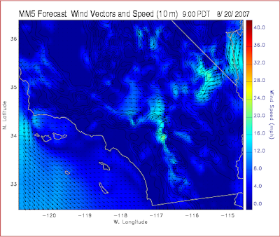
These images come from the Southern California Wildland Fire Hazard Center. The maps show favorable (flat) winds this morning however winds will increase steadily throughout the day from the West pushing from 8 to 18 MPH.

August 20 9:00 am


August 20 5:00 pm
Fire Location; Lat: 34° 46´ 45" Long: 120° 5´ 24"
(Just above the two Channel Islands on the left side of the map)

Zaca Fire perimeter map from August 19. Source SBCFire.

Labels: , ,