August 14, 2009
La Brea Fire Estimated Over 100,000 Acres
No, this is not a government estimate, draw your own conclusion as I have. The Zaca Fire burned over 230,000 acres in 2007 and took two full months (60 days) to control. The La Brea Fire has burned about a week and has consumed nearly half the acreage of the Zaca.
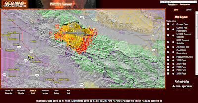
Look at the image below. The Zaca burn is the purple outlined area south of the La Brea. You will note the La Brea has actually entered the two year old Zaca vegetation and appears to be established in the old burn.
 What can we expect from here. If the current weather pattern persists we could see the Le Brea continue its E/SE trajectory and burn all the way to Highway 33, just like the Zaca Fire. This outcome is weather dependent, little done by the fire command so far has managed to stem the rapid growth.
Please follow my Twitter updates here.
Look at the image below. The Zaca burn is the purple outlined area south of the La Brea. You will note the La Brea has actually entered the two year old Zaca vegetation and appears to be established in the old burn.
What can we expect from here. If the current weather pattern persists we could see the Le Brea continue its E/SE trajectory and burn all the way to Highway 33, just like the Zaca Fire. This outcome is weather dependent, little done by the fire command so far has managed to stem the rapid growth.Please follow my Twitter updates here.
Labels: 2009 Fire Season, La Brea, La Brea Fire, Zaca Fire
Comments:
<< Home
Burn Acrage Estimate = NFG.
Assessment of Fire Outlook = NFG
In hindsight, not one of Fireman Mike's better posts.
Assessment of Fire Outlook = NFG
In hindsight, not one of Fireman Mike's better posts.
# posted by  : August 19, 2009 10:51 AM
: August 19, 2009 10:51 AM
I was close actually. Inciweb has the latest size update at just short of 90,000 acres.
By the time they burn out all the islands it will probably be revised closer to 95k acres.
Not a bad guess considering the command team were giving us bad/late data from the start on this one.
As far as outlook I expected the Forest Service to lay back and force it east into the Wilderness.
Frankly I am happy someone read the post.
Thanks for the comment.
Post a Comment
By the time they burn out all the islands it will probably be revised closer to 95k acres.
Not a bad guess considering the command team were giving us bad/late data from the start on this one.
As far as outlook I expected the Forest Service to lay back and force it east into the Wilderness.
Frankly I am happy someone read the post.
Thanks for the comment.

<< Home
